The Archaeological Site of Sounion
- Viewed - 566
Description
Cape Sounion, the southernmost tip of Attica, is a significant strategic point, whence the city-state of Athens controlled the sea passage to the Aegean Sea and Piraeus, the central port, as well as the Lavrion peninsula, comprising the rich silver mines thanks to which Athens emerged as a leading power in the 5th century BC.
The fortress and sanctuaries belonged to the deme of Sounion, formed through the state reorganization by Kleisthenes in 510 BC. The deme belonged to the tribe of Leontis and extended in the area between Lavrion, Megala Pefka, Kamariza (Agios Konstantinos) and the cape. The settlement in the fortress probably forms the center of the deme, of which more remains are also known. In the surroundings of the fortress, a settlement is located over the port and a cemetery of the classical period on the shore where the church of Saint Peter is, as well as part of a settlement of roman times west of the church.
Inside the fortress, the summit is occupied by the sanctuary of Poseidon. Entering through the gate at the NW part of the fortification wall, one ascended through the settlement which covered the slopes to reach the monumental gateway of the sanctuary. Nowadays, the visitor enters the fortress crossing over the east part of the wall. In the sandy cove north of the cape the port was located. On the rocky shore at the entrance of the inlet, ship sheds were cut out for warships to be hauled
Homer testifies to the sacredness of the area at least from the 8th century BC. In the archaic period (7th- 6th cent. BC) the sanctuary was thriving, though lacking monumental arrangement. Plenty of votive objects were found buried in depositors, gathered there following the destruction of the sanctuary by the Persians in 480 BC. At the end of the archaic period construction of a monumental temple of limestone began, which was destroyed by the Persians before being completed. The temple was rebuilt on the foundations of the previous one around 444-440 BC. In the classical and hellenistic times (5th – 2nd cent. BC) the sanctuary was frequently visited. A grand four-yearly festival was organized, officials sailing there in a sacred ship, as in the sanctuary on Delos island. With the decline of Greek religion the sanctuary was abandoned and the temple gradually decayed
The sacred precinct of Poseidon, occupying the highest area in the fortress, is defined by a wall except for its south precipitous side, on a surface of around 5000 m2. It was entered through a monumental gateway at the NE. The most important building is the temple of Poseidon, in the south part, while the NW part is occupied by the big north portico and the smaller west one.
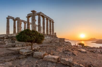
The doric temple seen today was built of local marble from the Agrileza quarries on top of the destroyed archaic temple. Palmette antefixes crowned the gable roof. At least the east pediment (on the entrance side) was decorated with statues. On the same side a relief frieze was running on the top of the interior of the colonnade. On the Parian marble frieze slabs scenes of the Centaur battle and the deeds of Theseus are sculpted, an allegory for the victory of the Greeks led by the Athenians against the Persians and for the superiority of the Athenian democracy over the eastern monarchy. The temple is attributed to the same architect with the ones of Hephaistos (?Theseion?) at the Athenian agora, Ares at Akharnes and Nemesis at Ramnous.
Administrative Information:
Ephorate of Antiquities of the Eastern Attiki
Sounio (Prefecture of Attiki)
Telephone: +30 22920 39363
Tickets:
Full: €10, Reduced: €5
Open:
9:30 until sunset
Last entry: 20 minutes before sunset time
Source: www.odysseus.culture.gr
Ephorate of Antiquities of the Eastern Attiki
Location / Contacts
- Address : Sounio
- Website : http://odysseus.culture.gr


